
|
|
I had a really good feeling about this day. The latest model runs were showing potential for good thunderstorms across N. Ireland on Bank Holiday Monday so there was no question in my mind that Roisin and I would be chasing this day. With CAPE values in the 900 range and lifted index at -3 it looked extremely promising with a trigger from solar heating in conjunction with a N-moving trough which would significantly aid with the formation of storms and all taking place in a weakly capped environment. The only negative aspect with the synoptics was that speed shear was weak, by this I mean that the wind speed did not increase with height which is a good indication of unorganised storms of the pulse type variety however this did not concern me in the slightest for this negative was counter balanced by the presence of a well defined large scale convergence zone. Convergence takes place when surface winds from different directions meet or 'converge', this is also known as 'surface convergence' and the area where this happens is called a 'convergence zone' or Cz for short. A Cz is a also a forcing mechanism allowing surface winds to ascend and lifting air parcels with them in the process which is turn reach their saturation level and hence form convective clouds which in turn should evolve into storms. Local scale rotation/turning is also a product of convergence so if the atmosphere can produce towering cumulus within this environment then the chances of getting funnel clouds and weak tornadoes increase dramatically. I can say with complete honesty that the majority of the most exciting and dramatic storms and funnels I have ever witnessed have took place within a Cz so needless to say I was very excited about this potential. I made sure to take a mental step back, slow down, and think carefully about where my target area was going to be.
I was up at 07.30 that morning and the reason for that was that I was too excited to sleep so in situations like this I like to get up and study every piece of information available which can help in making the correct decisions on the hours ahead. I was happy to see that the overnight cold front had cleared through quickly and sooner than I had expected which was great news because solar heating could commence and get to work on early morning convection below the border. What I loved about this set-up was that for the first time this year I would not have to undertake a long road trip to the border areas or into the Republic itself because all the models were silently screaming that the north was the best place to be today. I was overjoyed by this because it meant chasing in my own home territory which was as much relief as it was exciting because I know the roads well and have my own favourite locations from which to view storms so I already had an advantage over other days. This was also a Sly flow - I honestly felt like celebrating when I saw this - every other inland chase this season since April had taken place within Nly, NWly, and NEly flows which are bad to chase if you are in the N because you are forced to head far S in order to get into the areas of good CAPE and a location where convection will have time to drift and travel so you need to be there ahead of time to have a chance at all and more often than not storms fired way too far S beyond my mileage range which was heart breaking when you put in so much effort.
During this period I had spent a lot of time and money chasing these weird set-ups using up a lot of fuel and spending countless hours driving then coming home more or less empty handed. I did get to witness beautiful sunsets and sun pillars then later some dramatic pulse-type storm clouds however I never got that feeling of satisfaction from seeing something truly impressive. In my mind I have a selection of mental images of what I would like to catch on camera and if I don't get any of these then I get very restless, unsettled, and even quite moody, I quite honestly can't relax or focus on anything else until I achieve my goals so my way of dealing with this is to keep chasing every set-up possible and never ever give up until I capture something which I am very happy with, part of any success comes down to the decisions I make however a large part of it comes from nature herself so in truth I was really waiting for her to show the way. I finally felt that the tables were turning, on May 13th a surprise funnel cloud was rotating almost over my house which I honestly took as a sign that nature was finally noticing me and that this little treat was an indication of better things to come so I patiently waited for the next decent day and that was May 26th. I reviewed the charts that morning on my lap top and noted the large convergence zone located over the midlands and W parts of N. Ireland/Ireland so there was no question that we where going to be in that box by the afternoon, and furthermore this was a wonderful, joyful, delightfully Sly flow (thank goodness!) so it felt like everything was falling into place perfectly and at this point I felt like I honestly couldn't fail.
I spent hours glued to the lap top then by noon I took a break and lay down for 30 min's just to centre myself. When I once again checked the radar at 12.30 I was shocked to see that storms had exploded all over the W side of the country over Donegal moving N, it was shocking how quickly these had developed, we wouldn't be chasing these as they where too distant however it was a very good sign that things were happening and that the weak cap had been broken with convergence already working its magic. There was nothing forming over inland N. Ireland at all, in fact it was very quiet, however I sensed things could change very quickly and that we needed to be on the road with eyes on the sky, I am a big believer in watching convection even if there are no storms in the area because new updraughts can produce funnel clouds with little - or even in the complete absence - of precip so getting out and keeping a visual on building clouds is essential.
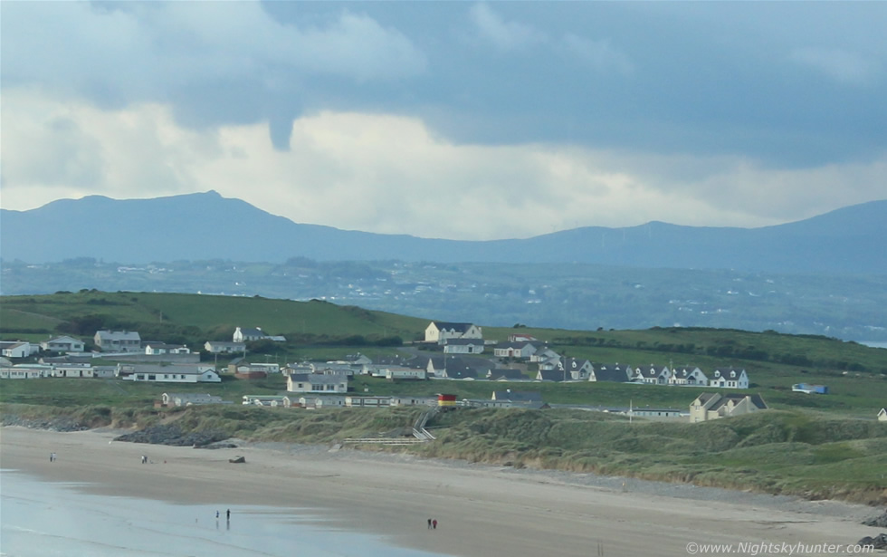
Roisin and I hit the road and were in top form, we were not in a rush so we were moving at a focused yet relaxed and controlled pace. We needed food and energy for the hours ahead so we got a nice chicken curry with rice meal made up for is in Maghera then parked at a country location not far from the main Glenshane Road. It was nice standing outside under the warm sun eating and watching white convection slowly grow against a blue sky while the birds sang around us, the day was getting warmer and warmer as the afternoon approached and I could sense that things were going to happen soon. We then relocated to Oak Leaf filling station on Glenshane Pass which become our base camp, it was very warm at this stage with strong heating and the station was busy with people coming and going on this nice Bank Holiday, I'm pretty sure Roisin and I were the only people there watching the sky hoping for storms. There were small black bases forming over the hills and I said to Roisin ''there are going to be funnels today'', I was certain of it, sometimes you can just tell by the look of the clouds and the feeling in the air, the slack flow was perfect for spin ups and with a Cz in the area the atmosphere was prime for funnel formation so we watched every cloud base just in case.
We got wifi so I got online to check the latest and by now it seemed everyone was onboard with this forecast. The Met Office had issued a yellow warning for heavy slow moving showers and thunderstorms with a risk of local flooding and their warning area matched the CAPE charts. Radar showed not even a drop of precip over N. Ireland yet however things had changed below the border where a large cluster of showers (green on radar) had formed just below the border to the S of the Fermanagh lake lands which where in the process of moving N over Lough Erne then eventually making a beeline for the W midlands. My plan was to wait and let that cluster of showers move N then in theory once they entered the Cz they should turn into storms or at least produce a funnel. We changed our location again to the top of Glenshane Pas and parked under small dark bases while a heavy shower suddenly dumped on us, patience was the name of the game, we simply had to wait then once those showers moved into the midlands we could shoot W and intercept them, this would be our main play of the day.
We waited, waited, waited, and waited some more and realised we had a lot of time to kill so Roisin suggested we move somewhere so we can go for a walk while we waited on things to happen, at first I was hesitant as I didn't want to move too far however I realised it was a good idea to get us out of the car for a while and get some much needed fresh air and exercise, the latter would also be good for dealing with the background adrenaline build up, I liked it however I said to Roisin it had to be somewhere with no tall trees so we could watch the sky at the same time, she thought for a minute then said, ''Benbradagh?'', that was a good idea because Benbradagh would be further W within our target area and the mountain would offer us a tremendous view of the sky so I could watch for funnels while we walked, it wasn't long before we were on the road once again.
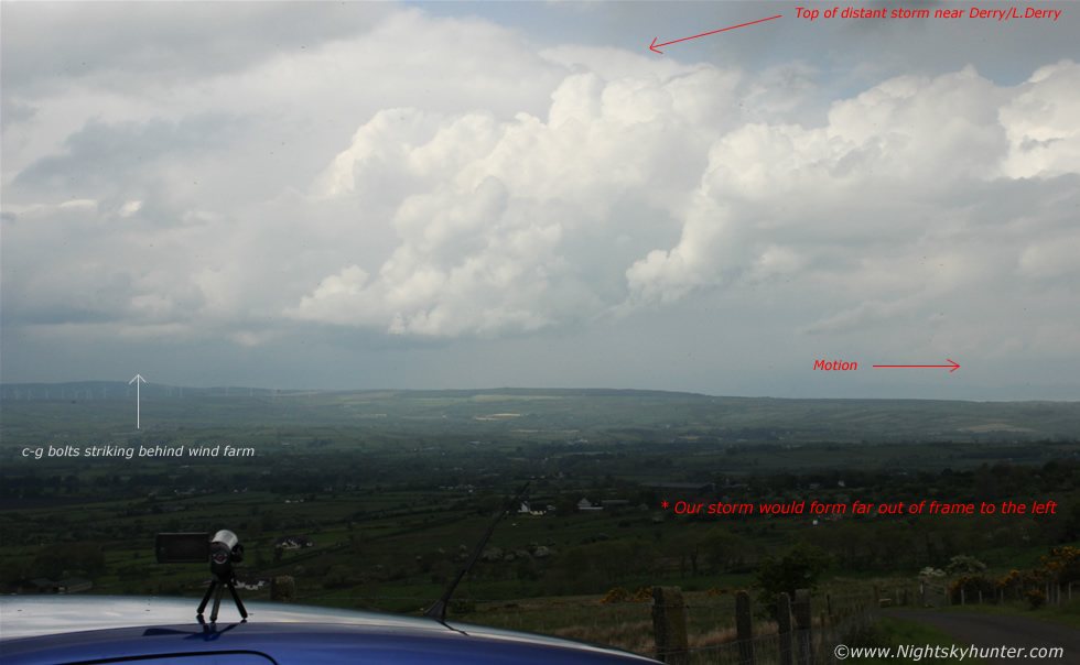 |
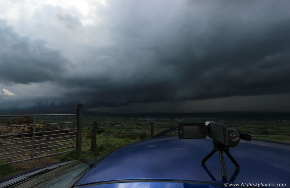
We drove through Dungiven then went W through the narrow country roads towards Benbradagh Mountain along the Sperrins and parked half way up. I opened the door to get outside and as I did so I casually looked W and saw a c-g lightning bolt strike down!!, talk about lucky to have been looking at the rite place at the rite time, the bolt was many miles away from those distant storms out W so it was quite amazing to see a bolt that clearly from this range in daylight. Here's an annotated image showing the scene, you can see the wind farm to the left where the bolt hit in the distance and in the foreground is new convection/cells forming while behind those is the top of the storms to the SW of Derry/L. Derry, all moving L to R in the image. I took that bolt as a lucky omen and set up my video camera with mini tripod on the car roof and filmed in that direction incase there were more, you can see this as a time lapse during the intro to the video below.
 |
The view from the mountain was utter perfection, this was our vantage point facing S which provided us with an unobstructed view across the country - a direction facing the Sly flow - so in theory we should see those showers on radar visually moving in from that area for miles in advance so I knew we couldn't have picked a better location - nice one Roisin. We walked up the steep mountain which was hard work, if you know the area then you know what I'm talking about it, the climb is even hard in a car. We reached the top and began our track back down the incline when we suddenly heard a distant rumble of thunder, we both looked at each other with a smile however just in case it was a high altitude plane we stopped and listened carefully - another rumble which despite its distance sounded angry, it was happening!.
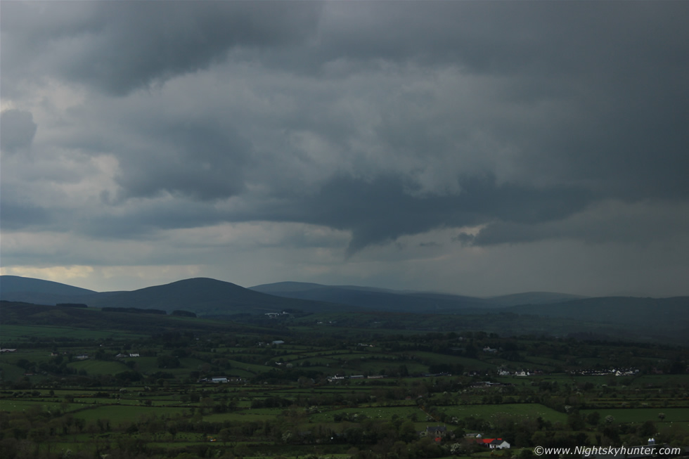
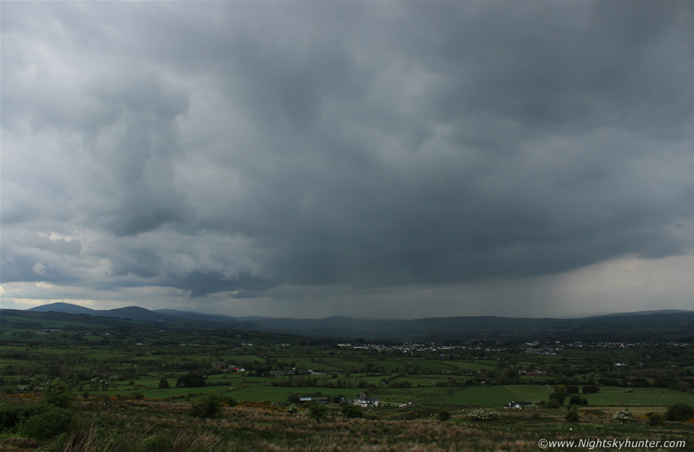
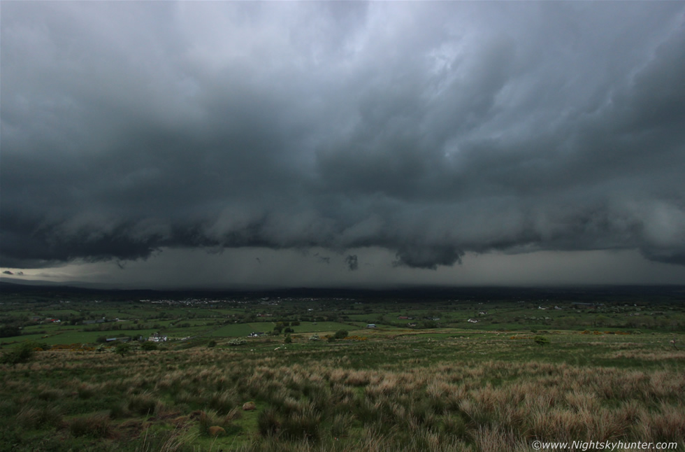
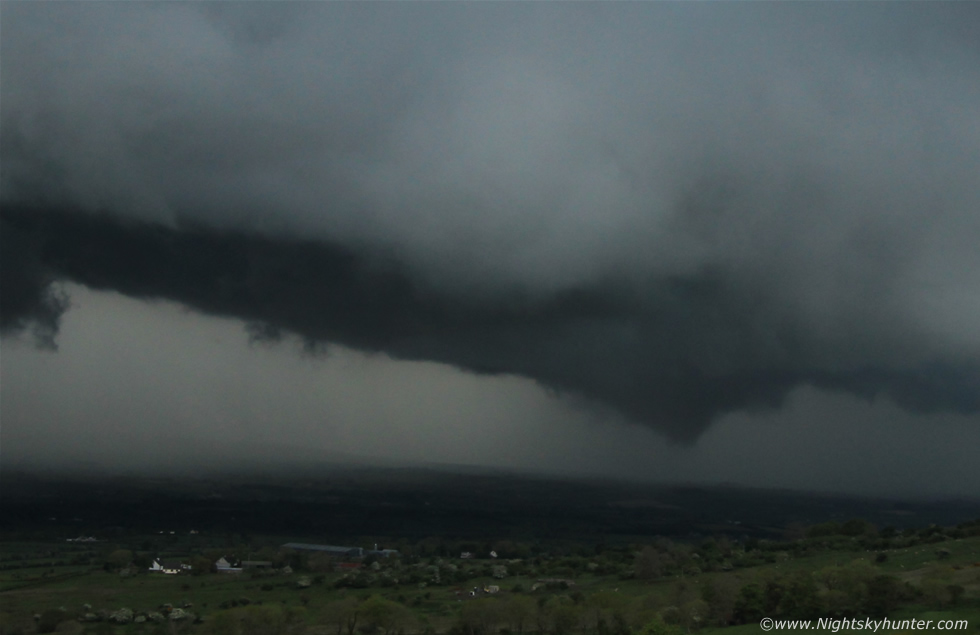
We got back to the car then I set up the video camera once again on the car roof facing S and began rolling in the area where a formation of clouds had formed to the S with light shower curtains falling gently across the landscape, these were that shower complex we had spotted on radar earlier which had now moved N into our target area and although it looked unexceptional at this point there were forces at work which in time would turn this into a beast of a storm. The rear (SW) end of that base was rain free and I noticed a thick long lowering of scud suddenly trailing from the back edge, it didn't look like normal scud and just then a familiar red alert went off in my brain, I watched carefully and soon that scud began to tighten up and rotate into a brief funnel cloud, I had just enough time to get a few still images with the 18-55mm kit lens before it dissipated, this was the view at 55mm.
 |
Cropped in closer, the funnel was rotating over the open countryside to the S of Dungiven which is out of frame to the right. I couldn't believe it, we just bagged another funnel cloud within half an hour of arriving here, the time was 13.52 UT, the vortex lasted approx one min and was at its most photogenic stage for perhaps 30-40 sec's and fortunately I was shooting it at that crucial stage, it then vanished rather quickly so although the sighting was brief it was no less exciting for it and as far as I was concerned this day was already a success so anything else which happened would be considered a bonus.
 |
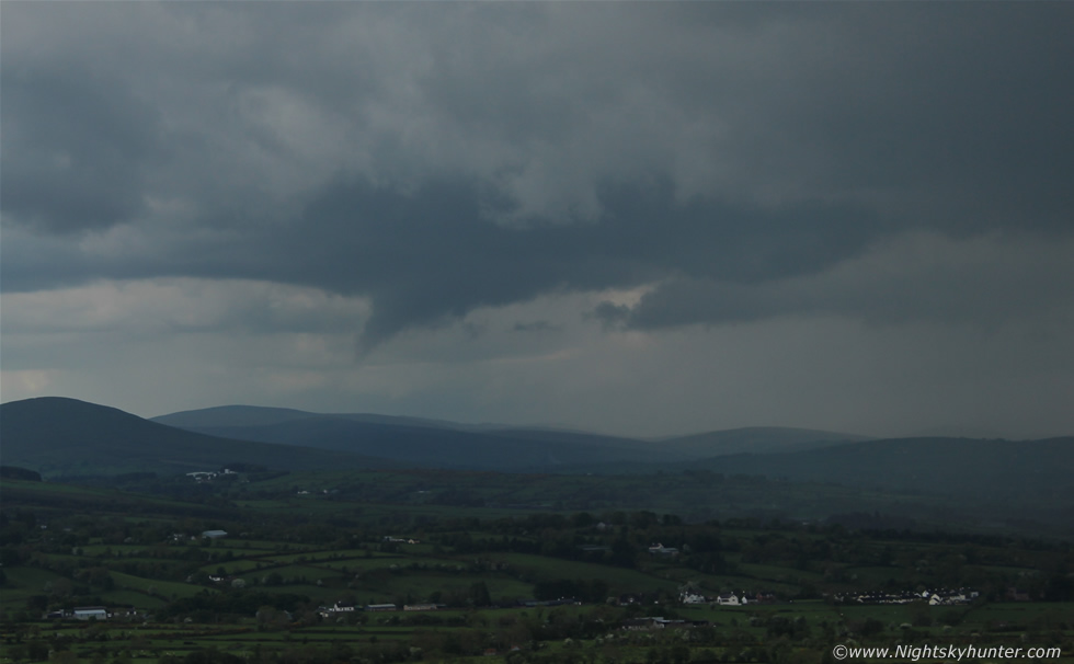
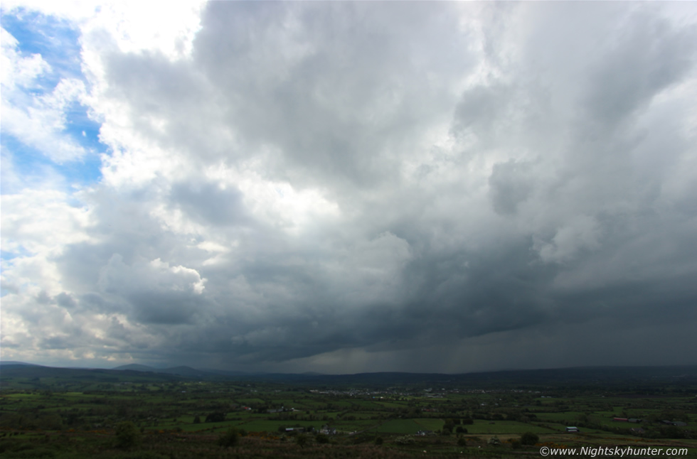
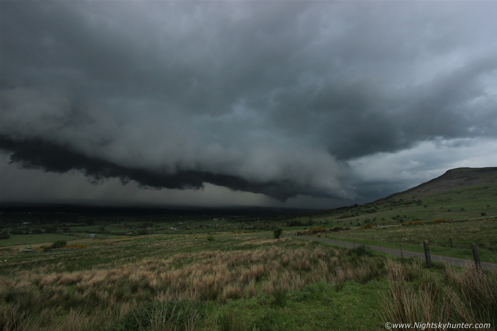
Wide angle image of the cloud base with funnel moments before it vanished, after it did so the base above it was still rotating for some time afterwards which was interesting to watch because it teased us with the suggestion that more funnels could be in store. As you can see from this image there was mid level cloud blocking the upper regions of this cell so I had no visual clue that something significant was brewing until the base intensified with time, this was really us watching the birth of an impressive thunderstorm.
 |
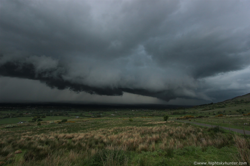
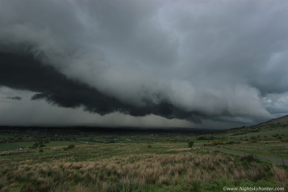
I had now switched to my 10-22mm ultra wide angle lens for the rest of these images. This is the same scene looking in the same direction 20 min's later and it was now clear a storm was forming, we could hear periodic rumbles of thunder from this direction but couldn't see any lightning so we kept watching and listening. Roisin did a couple more walks up the mountain by herself however after several closer rumbles she decided to stay close to the car and watch the clouds develop with me. It was clearly evident from casual observation that this was a line of young cells growing in an area of significant surface convergence because I could actually see this process at work in real time which was amazing to watch. This developing storm was incredibly slow however with time I could see that it was moving (S-N) L to R and ever so slightly towards us however behind me I could see large clumps of cloud moving from (N-S) R to L over my head and merging into the forming storm, I mean you could actually see the atmosphere organising and blending together like a perfect machine as the environment built a big thunderstorm piece by piece with clouds from the surrounding area, we were placed rite in the middle of a Cz and this process was utterly amazing to watch and I knew from this moment on that we were in business and that we were staying here for the duration of the storm.
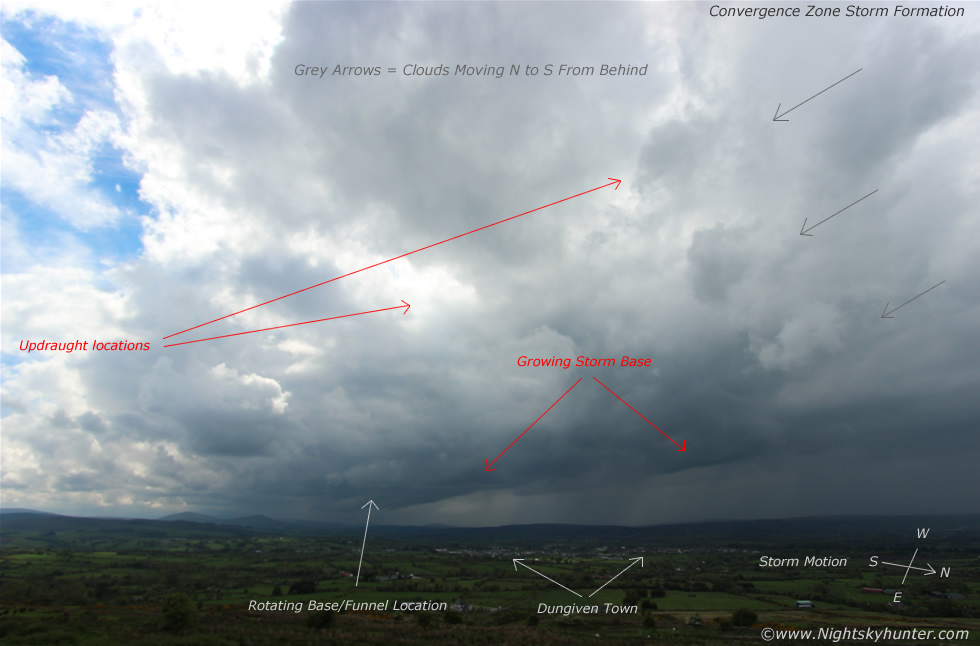 |
Same image with annotations to visually show what I was explaining above. Ever since I have been interested in storms there may only have been a small number of occasions when I had the luxury of watching a big storm grow in front of me in the same area without much movement while having the great fortune of not even feeling a drop of rain on my skin so that I could watch the process in complete comfort, it was like being in the best seat in the cinema all by yourself - for free - the only thing missing was the pop corn, and this was playing rite now.
 |
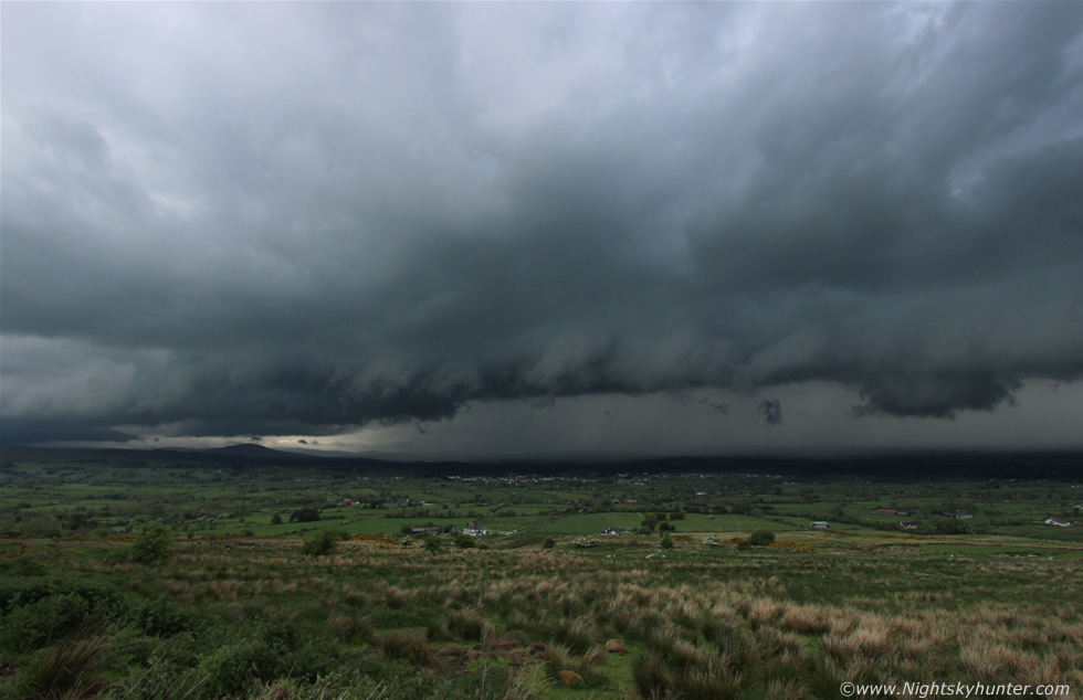
This is what the storm looked like 34 min's later!. Roisin and I watched as the invisible hands of nature created this brutal looking storm, the light was absolutely magic with the mountain all lit by hazy warm sunshine while on the landscape below a black monster was lurking with angry rumbles and flashes of lightning. What was astonishing was the fact that this storm didn't seem to be going anyway, it just looked like it was hovering over the countryside while building higher and higher by the minute, the base was huge with absolutely solid clouds and via brief glimpse through the cloud above I could see the white tops of several solid updraughts leaning overhead and as I watched the sunny clear sector to the E of the storm I could see new towers exploding up and feeding into the back of the storm as the line grew in length. We were filming with two cameras which was a really good set-up, I was using the HD video function on my Canon 600D with 10mm lens attached which allowed me to film ultra wide angle structure while Roisin filmed hand held with the Samsung HD video camera while occasionally taking stills and video with her own smart phone. However before that the Samsung was still filming from the car roof, if you look carefully on this image you can see it.
I got a phone call from my Dad at this time, he was on a fishing holiday in Co. Fermanagh however on this day he was near Mullaghmore on the W coast and was informing me of storm clouds building in the area and was wondering if Roisin and I where in the area. I said we were watching a brilliant thunderstorm rite now from Benbradagh and had just seen a funnel cloud then he heard a loud rumble of thunder across the line from our storm and said he would let me get on with my photography. The last thing I said was to keep his camera handy as there could be more funnels today.
 |
Full blown thunderstorm in progress yet amazingly it was still growing stronger and moving at a snail's pace over the lush fields below. It was pure black with thunder and random c-gs hitting which were now getting closer, I loved the fact that this beast was just hanging around this same area for such a long time and although it was slowly inching its way towards us it was doing so at such a slow pace that we could still watch and shoot it at our leisure while enjoying the warm humid afternoon with episodes of delightful sunshine, so we had a storm while catching rays at the same time. It's not often you get to experience that in this country, it really did feel like this was nature's reward after all the recent long distance storm chasing this season and I was savoring every second of it. Of interest, check out that cluster of buildings in the distance, that's the town of Dungiven and just look at the size of the storm above it. Angry teeth had formed on the S side of the line and it was obvious that a shelf cloud was forming with cool downdraughts of air (gust front) from the storm scooping warm moist air up ahead of it forming a shelf indicating that the storm would soon be reaching maturity and would soon become outflow dominant.
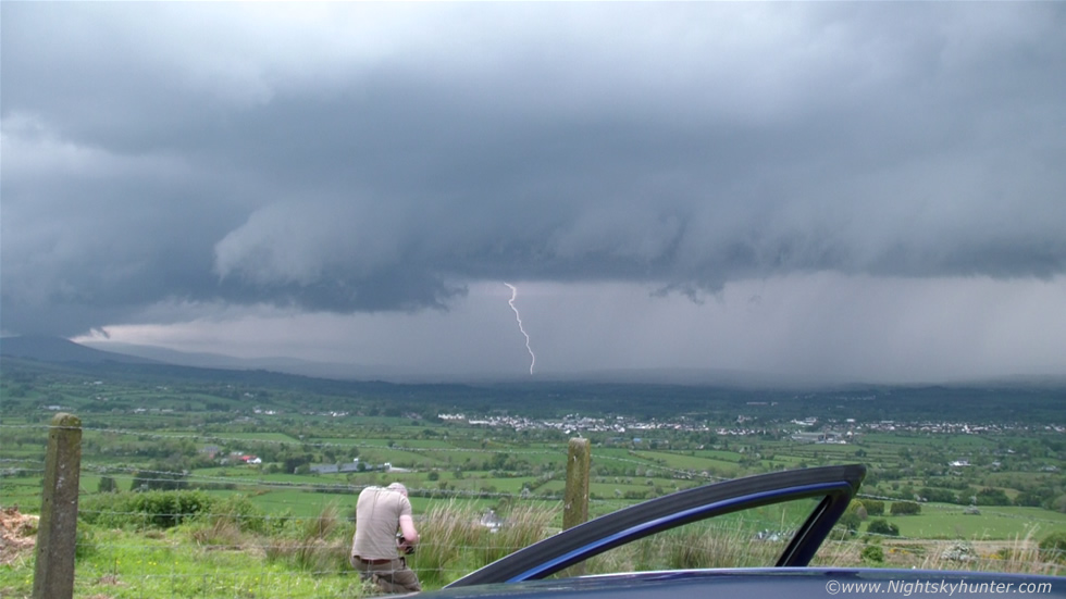 |
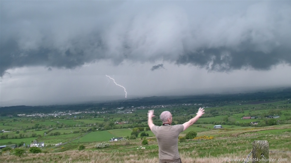
I climbed over the gate and got into this field to get clear of the wire as I wanted unobstructed foreground for my images. The pace had suddenly picked up with very dense curtains of rain and hail dropping for miles across the countryside in great sheets as the storm formed a shelf cloud at an astonishing pace, the motions going on along the leading edge were impressive with concentrated areas of rotation which looked like brief spin ups forming within the teeth. This was one of the cloud to ground (c-g) bolts captured by the Samsung from the car roof, the storm was pretty close and the thunder much louder and as the storm intensified so did our adrenaline, we were truly in the zone here and loving every second of it and there was a great sense of rush as we knew that time was running out as the storm was gaining ground on us so we needed to get as many images and video footage as possible before the precip hit us.
 |
The storm now looked like something over the great plains of the USA with nice solid mean structure throwing out c-gs and rumbling away, Roisin loved the sound of the thunder over the open countryside, I was telling her earlier about how different thunder sounds out in the open in the hills and now she understood what I meant, there really is something special about a storm in the wide open countryside, on this mountain it was completely quiet with only the birds and sheep making any perceptible sound so you can imagine how the acoustics of a storm would feel in this environment. Thunder seemed to roll and echo across the mountain and valleys and took on a persona all on its own. I can tell you there is no better experience than coming face to face with an approaching storm out in the open away from every day noise, buildings, and busy roads, we perceived it as a personal experience as if we were having a communion with the storm.
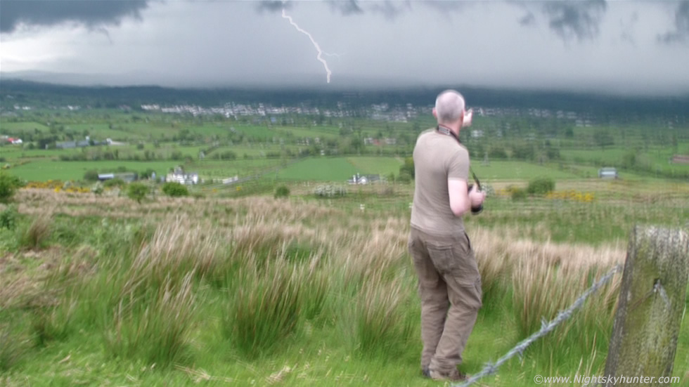 |
I asked Roisin to use the Samsung video camera and film the storm hand held for a more POV style of shooting and I liked the fact that she got me included in the frame for a sense of scale and for that added human dimension. She did me proud and got two wonderful close range c-gs, this was the first which hit the ground just as I was pointing out aspects of the storm to Roisin, notice the second order branching.
 |
There was no question the storm was making a bee line for us and the thunder was getting louder while a feeling of danger became notable as it just dawned on me that we were entirely exposed out in the open on a mountain with lightning however the car was only 10ft away from us and that was the safest place we could be. I knew from observation that all the lightning I saw was taking place within the precipitation area so in theory we would be fine until that precip hit us, I wasn't going to stay out until that happened however I wanted to wait a little longer so that we could get personal with this storm and its often during these close range encounters when the best structure images with a wide angle lens can be taken and that's what I was after.
 |
Structure shot of the year for me, in fact, this was the best daylight storm structure I have seen since 2009 and yet again it looked like something from the US. This was 10mm extreme wide angle which is an absolutely huge field of view and yet the storm cannot even fit in the frame with a large portion of it extending far out of frame to the left while moving L to R and towards us at the same time. The low level and mid level structure was amazing as this beast seemed to hover menacingly over the countryside with solid shelf cloud along the leading edge and silvery hail curtains falling behind, note the size of the houses and barns compared to the storm for a sense of scale. Periodic flashes would appear from within the precip accompanied by c-g bolts along the front of the curtains at very close range. You have to appreciate that this storm and its lightning was considerably closer to us than this image shows because ultra wide angle lenses tend to push subjects further away however in reality the nasty scud sections on the shelf were almost above our heads at this point.
Despite being a linear storm I noticed well defined rounded elements within in the shelf which spawned fantastic areas of rotation, in fact, when this image and the others below were taken we could see three impressive areas of rapid rotation located within the dark underside of the shelf and for a while I thought a tornado was possible. Funnels and tornadoes mostly form at the back of a storm or at least under an updraught however it is common to get brief spin ups in shelf clouds too in the form of funnels and weak tornadoes due to the kind of dynamic mixing and forcing which takes place associated with the gust front, these features are more common with squall lines however they were rotating like made rite before our eyes with this storm. Note that dark inverted cone shaped lowering to the far right, considering the rotation we were observing on our side of the storm I would suspect that lowering was doing the same.
 |
Roisin's second c-g catch of the day and this one was rather humorous because I look like I conjured up this bolt using my arms, check it out on the video, by the way those dark clouds were rotating too when the bolt struck. Roisin observed that the sheep sounded scared with the loud thunder however I think she may have been speaking about herself, Roisin kept asking if we were safe and I didn't blame her, we would be taking shelter any min but first some more structure shots were needed.
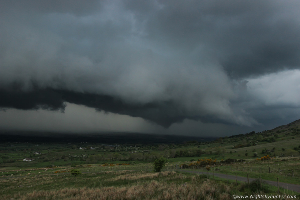 |
22mm of the N end of the storm showing that inverted cone lowering, I guess we may have been close to getting another funnel or even tornado here however we would have needed to have been closer to tell for certain and our observation of it was brief as we were getting distracted by the lightning and concerns about our own safety.
 |
Deep crop from the above image. I was so proud of Roisin because despite all the close range lightning and the element of danger she never stopped filming and continued to document the structure while combating that growing anxiety from the unnerving questions about where the next bolt was going to strike.
 |
Another full 10mm structure shot this time with Benbradagh mountain itself in the frame. Not long after this image was taken the suspicious lowering became more loose and blocky as cold air from the precip undercut any moist air it was feeding on.
 |
Big shelf cloud with vivid rotating elements and dramatic lifting along the lip now almost overhead, this was definitely the best shelf I have captured since the stunner over Ballyronan during June 2009. I suddenly felt this strange sensation above my head as if the atmosphere was highly charged and I immediately sensed danger and that a bolt in our area was due at any moment so I ran back, climbed over the gate and got back in the car, Roisin was already waiting inside.
 |
I turned the car around to face E then we watched the storm pass over us with majestic curtains of hail falling from the black clouds aloft. We filmed through the front windscreen together for close range bolts however they seemed to be embedded within the precip so we kept shooting and taking stills anyway as the clouds were truly amazing, we could almost feel the clouds if you know what I mean. To get even more personal we drove to the very top of Benbradagh in an area completely exposed to the elements, we were the highest object on the mountain and the sense of vulnerability was more than tangible. We watched lightning and heard thunder, some of the latter sent slight vibrations through the car, this mountain top lightning encounter reminded me of my very first official storm chase back on July 16th 2007 when Conor McDonald, his girlfriend, and I experienced fierce lightning activity from the top of Slieve Gallion and reflecting back on those memories made me smile, I love this stuff and I am truly happy to be doing this kind of photography, I feel it is in my blood.
A new core erupted to life on the W side of the storm and passed rite over us producing a nasty hail storm, the hail stones were only pea sized but they were numerous and hard which made a nice din on the car roof, I had the window down and hail stones were falling in and bouncing on the dash and steering wheel which was cool. The storm kept producing as it moved N then weakened so we turned around and headed back down the mountain again to be greeted by torrents of rain water running down the mountain road. Once on ground level we were shocked by the amount of water on the roads, it's a good job there were no rivers nearby this town or a serious flash flooding event was likely. Dungiven and the surrounding area experienced serious rainfall from this storm and it was no surprise when you think that this storm has been practically hovering over the same area for several hours dumping rain and hail the entire time. Once on Glenshane Pass the weather changed from wet to dry and it was clear that no storms had happened back home and that we had experienced one of the main events of the day. I have to say I was buzzing for a week after this chase because it was utter perfection (which is rare to experience), my own personal forecast and target area was perfect and the storm itself was perfect, not to mention the rarity of experiencing a stationary storm in N. Ireland through its entire life cycle from birth to death for over two hours which was a memory I will never forget, and to have Roisin with me when it happened - she has been through many bust chases with me this year - made it even more special, thanks nature!.
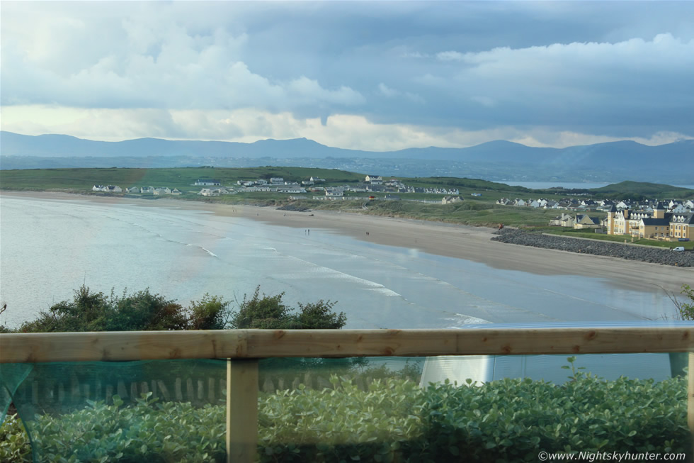 |
When I got home I learned that Tyler Collins had observed and captured two more funnel clouds near Derry/L. Derry this very same evening however that was not the end of the excitement from this day. A few days later I met my Dad again - remember the phone conversation we had during this storm - and he had some news for me. Dad had captured a funnel cloud over Donegal Bay which he documented on still images and video using this Canon 600D, and better yet he did all this from a restaurant at Rossnowlagh, this is the wide angle view looking N from this location.
 |
Close crop of the funnel which was rotating from high based convection which had no doubt been generated by sea breeze convergence. The funnel looked solid and very substantial, Dad even drew some attention because of what he was doing and several people asked what he was photographing so he used the opportunity to explain to a lady and her son all about funnel clouds which I'm sure got them interested in the sky too. That makes four funnel clouds over the country on Bank Holiday Monday. This was also my Dad's first ever funnel cloud catch and I was well chuffed when I saw the images, perhaps storm chasing is in our blood, nice work Dad!
Full HD video of the entire life cycle of the Dungiven thunderstorm filmed at 10mm and through the Samsung by Roisin and myself featuring the funnel cloud, c-g lightning and the brutal cloud structure as the storm approached us then ending with the hail core on the top of Benbradagh.
Short video clip of the Donegal Bay funnel cloud filmed by my Dad on the same evening from Rossnowlagh, if you look carefully you can see the funnel rotating and bending towards the end. May 26th was a very exciting day and I suspect more spectacular weather will be in store in the very near future, thanks very much for reading.
Martin McKenna